The Upper Peninsula of Wisconsin?

The story of the attachment of the Upper Peninsula to Michigan is connected to the controversial “Toledo Strip” that strip of land between Ohio and Michigan. Upon closer survey of the documents, it is found that there was a movement coming from the extremely western end of Michigan Territory – Wisconsin – in the 1820s to be created as a territory, by Congress, which would include the Upper Peninsula.
The origins of the development of the territories and states of Michigan and Wisconsin go back to 1783.1 At that time General George Washington identified the area to the northwest of the River Ohio that should be defined and set-up for settlement. In October 1783, Congress adopted the region, to control the “red man.” Then in March 1784 Congress instructed a committee, chaired by Thomas Jefferson to fashion a plan for the entire Northwest, which he did. He divided the Northwest on parallels of latitude into ten projected states with severely classical names: Sylvania, Michigania, Assenisipin, Illinoia, Polypotamia, Chersonesus, Metropotamia, Saratoga, Pelisipia, and Washington.2
It was taken up by Congress on April and adopted on April 23, accepting his system of territorial divisions however the names were dropped to be ultimately decided by the incoming population. This Congress of the Confederation government created the Northwest Ordinance on July 13, 1787.
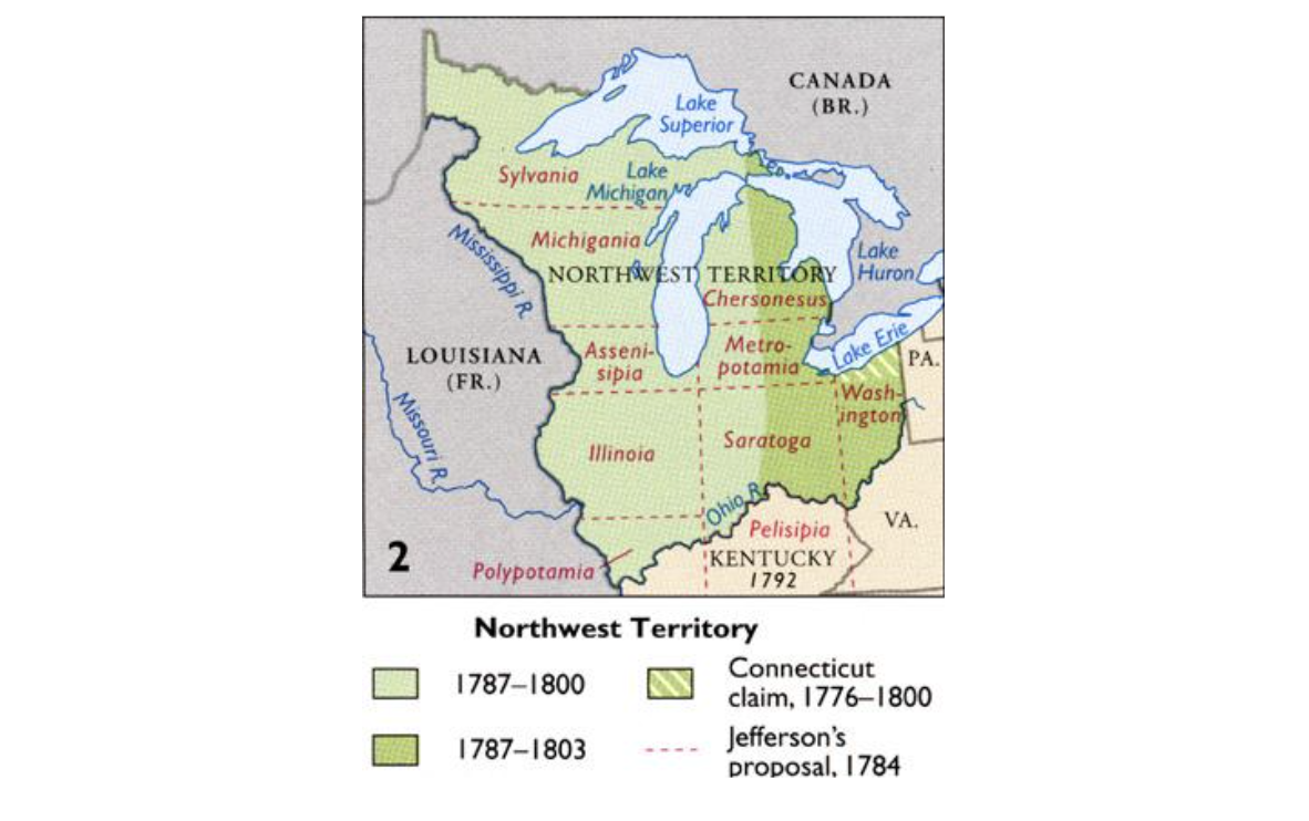
It was a complex bill that created the mechanism for new states to join the Union, but for our purposes we are interested in the space. The northwest was the land west of Pennsylvania; north and west of the Ohio River; western limit the Mississippi River per treaties of Paris (1763 and 1783); and north British America. It was not to be less than three or more than five states. This was the document that was the basis for future discussion and developments.
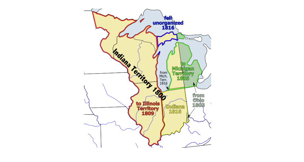
The state of Ohio was established in 1803 and at that time Indiana Territory was formed which consisted of the future states of Indiana, Illinois, Michigan, and Wisconsin. The people of Michigan, at Detroit, Mackinac and Sault Ste. Marie were upset that they had to travel far south of Vincennes, Indiana over 414 miles to conduct legal and territorial business. As a result in 1805 Michigan Territory was created.
Then the War of 1812 interrupted the settlement of the west. After the war’s end in 1815 peace returned to the western frontier and settlement was reactivated and it soon followed that Indiana (1816) and Illinois (1818) became states. On April 18, 1818 Michigan Territory expanded to include Wisconsin and portions of Minnesota to the Mississippi River.
Now we focus on the future state of Wisconsin. Settlement began in the seventeenth century. In the north at the Chequamegon Bay on Madeline Island and in the vicinity of modern Ashland, the Jesuits in the 1660s and then later missionaries and fur traders established settlements. Green Bay has been visited by the Marquette-Joliet expedition of 1673 as they paddled up the Fox and down the Wisconsin Rivers to the Mississippi. It became a fur-trading center closely connected with French and British settlements at the Straits of Mackinac and the U.S. Army post, Fort Howard was established in 1816. At the confluence of the Wisconsin and Mississippi Rivers in western Wisconsin the fur trading and military post of Prairie du Chien was developed in the late seventeenth century. The U.S. Army established Fort Crawford in 1816. Portions of the state were visited by the Lewis Cass expedition in 1820 and quickly became known to the public through newspaper coverage.
The first Prairie du Chien petitioners submitted their concerns to some congressmen in the winter of 1819. They suggested that there should be one court that would meet in the different counties during the summer and at the court of the judge’s residence in the winter. The great distances were presented as the major stumbling block. This was followed by another request by those at Prairie du Chien (Crawford County), Green Bay (Brown County) and Mackinac (Michilimackinac County) in November 1821. Again their major complaint was that they were isolated settlements: Prairie du Chien was nine hundred miles, Green Bay six hundred miles, Mackinac four hundred miles, and Sault Ste. Marie five hundred miles from Detroit. Earlier Detroiters protested having to travel 414 miles through more hospitable country especially during the winter. They further pointed out that the country lying west of the Mississippi River, formerly part of the territory of Missouri was left without any government with the admission of Missouri in 1820. For all of these settlers, all legal matters and justice had to be conducted in Detroit. At least they should have a superior court in the region.
The majority of the inhabitants were French and since 1796 when the United States took over the Great Lakes country they had little communication with Detroit and continued to follow the Ottawa River trade route to Montréal or traded with the British coming from the north through Hudson Bay. They were so isolated that they concluded, “they might as well be attached to the State of New-York, as to the Peninsula of Michigan.” Furthermore when they forced to leave the Northern District and venture to Detroit they entered “a land of strangers.”
The court at Detroit held one term beginning on the third Monday of September and continued for four weeks. If the trial had to be continued the individual had to spent the winter at Detroit at his/her own expense.
Furthermore, these inhabitants were fur traders and to be “locked” in Detroit over legal issues meant that they could not pursue the trade to the west. In order to seek justice these people had to destroy their businesses. So they concluded that inhabitants of the Northern District faced a “complete denial of justice.” And finally the laws of the United States tended to be little known and could not be executed.
In September 1824 they petitioned Congress once again. For these people nature had erected a barrier of distance that precluded the possibility of a real connection to the United States. They had no recourse to justice if local officials were incompetent or dishonest. Again they reiterated that for all purposes of government and justice they could be attached to the state of Ohio, Pennsylvania or New York as Michigan Territory.3
Focusing on the economy, they pointed out that the region through the sales of Indian traders brought $800,000 to $1 million to the United States. Having a realistic court system would further allow businesses to operate and deal with financial problems among American traders or outside companies: North West Companies and the Hudson’s Bay Company. If properly dealt with the region could develop a solid and expanding economic base.4 Three copies of these documents were affirmed with the signatures of the inhabitants at Prairie du Chien, Green Bay and Michilimackinac. At another time it was pointed out that many of the inhabitants were French and were unfamiliar with the US Constitution nor understood how the law operated and how they could deal with legal problems. They also faced problems with land claims and encroachments by the military. Again what to do with incompetent or lawless officials was presented as an issue.5 These were some of the earliest requests for people of the Northern District to be dealt with as American citizens.
There was also another major issue, which Judge James Doty introduced in 1823 – election results from Wisconsin would reach Detroit after the final results had been announced. Thus these people saw little reason or effect of participating in an election. Personally he noted that in warm weather it was a fifteen-day canoe trip from Mackinac to Prairie du Chien and “fortunately few mosquitoes.” They were truly isolated from the United States.
In May 1825 Doty wrote to Henry R. Schoolcraft that he was submitting his name to run as a territorial representative. There were problems facing him. The territorial legislature in Detroit desired to hold its sessions during the winter and as a result few people were interested in serving. However Doty for the common good submitted his name.6
There was pressure from the inhabitants of the western Michigan Territory for action beyond petitions to Congress. Direct action was needed. In 1824 Judge Doty had interested the promoter of western expansion of the United States, Senator Thomas Hart Benton of Missouri to get a bill through Congress erecting “the Territory of Chippewau.” Doty, with the written support of the inhabitants forwarded a bill that he had written in November 1824. Boundaries sought by the Doty bill were:
All that part of Michigan Territory included within the following boundaries, that is to say: On the south by the northern boundary line of the state of Illinois, crossing the Missouri river at the head of Rock Island, and by the northern boundary line of the state of Missouri; on the north by the boundary line of the United States to the southern extremity of Drummond Island at the mouth of the river St. Mary, and thence be a line running from the said island to the southern extremity of Bois Blanc island in Lake Huron, thence by a line equally distant from the island and main land to the centre of the straits between Lakes Michigan and Huron, and thence up the middle of the said straits and Lake Michigan to the northeastern corner of the state of Illinois.7
The matter dragged along for some time without action, although Doty persistently wrote letters explanatory of the situation to numerous influential congressmen. In 1827 we find Doty willing to call the proposed new Territory of Ouisconsin. This celebrated the major river flowing through the region the Wisconsin River. The term referred to the Miami word, Meskonsing meaning “this stream meanders thru something red – possibly the Dells. The French did not use the letter “W” and created the sound with the “OU”. The Americans changed the French “OU” to “W”. Then the settlers called their proposed territory – Huron as it looked like action would be taken in Congress. In February 1828 the Committee on Territories in Congress was set to take action with the territorial idea.
Suddenly unexpected interference set in from Detroit. The citizens of Detroit sent a memorial dated February 18, 1828 to Congress. They protested that the new territory would include the peninsula between the waters of Lakes Superior and Michigan together with Mackinac, Bois Blanc, and other islands in the Straits of Mackinac. For a long period there had been commercial and social connections between Detroit and the communities of Mackinac Island and Sault Ste. Marie. They noted that there was no commercial interaction between the latter places and the Mississippi River at Prairie du Chien’s doorstep and their trade could move down the river to St. Louis. The summer water route eased communication between Detroit and the northern settlements and there was a land route, which had been developed that allowed mail to pass through the winter. This was not possible with the settlements to the west. The memorialists called for the boundary line to follow the January 11, 1805 line from the southerly bend of Lake Michigan northward through the middle of the lake, across the Upper Peninsula and connect with the international boundary with British North America in Lake Superior. They supported the Territory of Huron, which would have included the Upper Peninsula from about Naubinway, Michigan at the head of Lake Michigan westward as noted on a historical marker.8
This memorial sent the issue back to committee. In 1830 Judge Doty renewed the effort in a bill to establish the Territory of Huron, with the same boundaries as those prescribed for Chippewau. No action was taken at this time. In 1834 after several sessions of lobbying, a substitute was offered, entitled “A bill establishing the territorial government of Wisconsin,” with boundaries the same as before, except that the country to the east of the “Mackinaw meridian” (modern I-75) was not now claimed. A committee of the House of Representatives reported in 1833 “the due line north of Mackinaw should be retained as more in consonance with the ordinance of 1787.”
Then more trouble emerged with a concern from the state of Illinois, when the people of the territory of Wisconsin promoted the idea that the southern limit of the new territory should be the southern limit of Lake Michigan. This was an in surmountable obstacle as it brought a state and future territory into conflict and the state would win such an effort. Actually the boundary between Illinois and Michigan at the southern end of Lake Michigan was settled in 1830.
The bill hung fire on account of the Ohio-Michigan dispute – Toledo Strip, which began in 1832. In 1834 Michigan Territory was enlarged to include Wisconsin but also Minnesota, Iowa, and eastern sections of North and South Dakota. However Michigan moved ahead with unofficial statehood and filled positions as a state. As the 1836 presidential election came into focus Congress was not going to alienate Ohio, since territorial Michiganders could not vote in a presidential election. So Michigan was left without the thin Toledo Strip.
Lucius Lyon, a land surveyor with a detailed knowledge of Michigan’s geography and a territorial representative in Congress made a persuasive argument for Michiganders to surrender the Toledo Strip for the Upper Peninsula – bound by Lakes Huron, Michigan and Superior, the Menominee River, a strip of land and the Montreal River. However many Michiganders were “outraged” that they had to do something extra to become a state. As a result although Arkansas, the southern slave state was admitted into the Union in June 1836, the acceptance of the U.P. had to wait until December 14, 1836 when the frostbit convention meeting in Ann Arbor accepted the compromise and Michigan became a state a month later on January 1837.9
Wisconsin, the fifth and last division in the Northwest Territory, was stripped of the northern territory- Michigan’s Upper Peninsula. So an “upper peninsula of Wisconsin” was lost.
References
1A classic study of this movement to create the Territory of Wisconsin in the 1820s is: Reuben Gold Thwaites. “The Boundaries of Wisconsin with a General Historical Survey of the Division of the Northwest Territory into States,” Wisconsin Historical Collections Vol. 11 (1888 ): 451-501. It contains an excellent collection of maps that help to understand the story.
2Malcolm Townsend, compiler. Handbook of the United States Political History for Readers and Students. Boston, Mass.: Lothrop, Lee and Shephard Company, 1906, pp. 32-33. Meanings: Sylvania- forest land; Michigania- land of large lake; Assenisipia- native term for Rock River; Illinoia- land of Illinois River; Polypotamia- many waters; Chersonesus- Greek for peninsula; Metropotamia- mother of rivers; Saratoga- celebrated New York battlefield; Pelisipia- Cherokee name for Ohio River; Washington- President Washington.
3“Petition to Congress by Inhabitants of Brown County,” September 28, 1824, The Territorial Papers of the United States. Vol. 11 The Territory of Michigan, 1820-1829. Washington D.C.: Government Printing Office, 1943, pp. 588-591.
4“Observations,” in Carter. The Territorial Papers, vol. 11, pp. 162-168.
5“Petition to Congress by Inhabitants of Prairie du Chien,” December 24, 1821 and September 28, 1824 in Carter. Territorial Papers, vol. 11, pp. 211-213 and 588-59.
6Judge Doty to Henry R. Schoolcraft, Prairie du Chien, September 10, 1823 and Judge Doty to Henry R. Schoolcraft, Munnomonee, May 24, 1825, Carter. Territorial Papers Vol. 11, pp. 404-405 and 680-681.
7Thwaites. Wisconsin Historical Collections, p. 464.
8“Memorial to Congress from Citizens of Detroit,” February 18, 1828, Carter. Territorial Papers, pp. 1167-1170.
9Russell M Magnaghi. The Upper Peninsula of Michigan: A History. Marquette, Mich.: 906 Heritage Press, pp. 63-64.

Great story of Michigan.
Growing up in Ironwood I don’t recall ever being taught why we were not part of Wisconsin. Or maybe I was absent that day?
Well done history as always. Thank you Dr Magnaghi.
Geography is destiny. Connected to it’s historically assigned state, Michigan, by one four lane bridge, with occasional three hour backups during the tourist peak. Once the bridge is crossed, only two roads go west, mostly two lane.
St Ignace to Ironwood equals 300 miles of mostly empty space. Ironwood to Detroit is 600 miles (a shorter shopping trip would be Chicago, 400 miles). For visitors from the urban centers of the lower half of the Lower Peninsula, getting to the Porcupine Mountains feels like forever. I-35 interstate takes tourists directly to Canada, where there is seriously rugged and remote land to enjoy.
Logically, the UP should be joined to Wisconsin, at least in terms of the history of statehood debates. Wisconsin tends to lean Democrat so the Democratic legislators of Wisconsin will not ask a mostly Republican UP to join their state. The proposal to create the State of Superior fizzled for a bunch of reasons including the cost to Yoopers to pay the bills for a remote place with limited economic resources.
Here’s a good discussion of the situation. By the way, we spend summers in the UP and love this place.
https://agupdate.com/opinion/column/michael-trinklein-superior-could-be-our-nations-51st-state/article_31512902-01bf-5e29-9955-f9af8b90e05c.html
Thanks again Dr Magnaghi, glad to see you are continuing to produce interesting history! We spent a few days a couple weeks ago in Mineral Point and Spring Green Wisconsin…interesting place for Wisconsin history with lead and zinc mining there in the early 1800s. Mineral Point is an A list little town, with more National Historic Register buildings and homes per capita than I have ever seen, most of them pre 1850. Links to the U.P. abound, the area was settled by Cornish miners and businesspeople. Restaurants and bakeries still serve pasties , saffron buns and other Cornish delicacies….I must assume some of the Cornish moved up to Michigan in the copper and iron booms as they represented a ready supply of skilled miners and technicians.
We will NEVER be part of either the State of Michigan nor will we ever belong to Wisconsin (again); I find both the modern-day usage of terms like Upper Peninsula “of Michigan” offensive as they’re nothing more than an owner that literally doesn’t care about its subjects in the “backwoods” of Da Yoop. The very same would be true for Wisconsin; Wisconsiners, like Michiganders, do NOT have our best interests in mind and would not pay us any mind in the long-term. I don’t like the title of this article and I hope that U.P. interests can be respected and not overlooked by outsiders.
WIS CON SIN. That says it all! Thanks Doctor! Well done!
Here’s the solution:
If Yoopers don’t want to be part of MI or WI, and want more independence and self-governing authority.
BECOME A U.S. TERRITORY
“Red man” — do you think putting it in scare quotes makes the term sound less racist/more academic? It’s difficult to take the rest of this article seriously when it starts out with such ignorant language.
Glad to see this article about the early history of the Upper Peninsula. Professor Magnaghi is a veritable treasure trove of information about so many aspects of the UP’s history. For more history about the Lake Superior Region, including the Chequamegon Bay area and Hurley on the Penokee-Gogebic Range, I recommend. Eric Olmanson’s. “The Future City on the Inland Sea,” An Imaginative Geography of Lake Superior. [Ohio, 2007]. Eric gave a power point presentation on this topic at the annual Gilbert J. Endrizzi Memorial Lecture at the Iron County, Wisconsn, Historical Musuem in Hurley, in July, 2019. This year’s program featured Donald Lafreniere, Chairman of the Department of Social Sciences at Michigan Tech. Professor Lafreniere discussed Tech’s geospatial “deep mapping” digital atlas, “Keweenaw Time Traveler.” Other presenters at this event have included scholars Steve Lehto, and Jeffrey Suzik. Professor Magnaghi has presented in Hurley [appropriately] on his book about Prohibition in the UP and in Hurley, at one time “the Skagway to the Klondike.”